Tai Hang – Fire Dragon Path ca.1924

360-degree panoramic artwork developed from historical photos
Historical Hotspots:
China Sugar Refinery
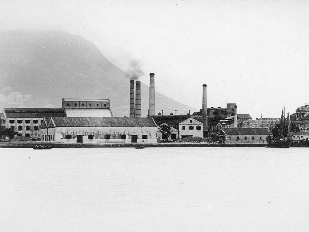
Causeway Bay has long been a bustling area in Hong Kong. From the second half of the 19th century to the 1920s, it was the industrial centre of Hong Kong. In 1866, the Hong Kong Mint was established there to mint coins of different denominations for the government, as well as silver pieces and bars for local banks and merchants. However, it closed down in 1868 due to a shortfall in orders. The site was subsequently sold to Jardine Matheson, which developed it into Hong Kong’s first sugar refinery, the China Sugar Refinery. The sugar refinery started operation in 1878, with warehouses, factories and offices built on the premises, along with a deep-water jetty for unloading raw materials and loading finished goods.
The sugar manufactured in Hong Kong was sold in China and exported to the Middle East, Southeast Asia, North America and Australia. However, keen international competition in the sugar industry brought the business closure in 1928. In 1879, Jardine Matheson also established the Hong Kong Ice Company near the sugar factory, which was merged with the Dairy Farm Company in 1917 and continued operation until the 1970s. The original site is now the Windsor House and Hang Lung Centre.
Photo courtesy of The National Archives of the United Kingdom
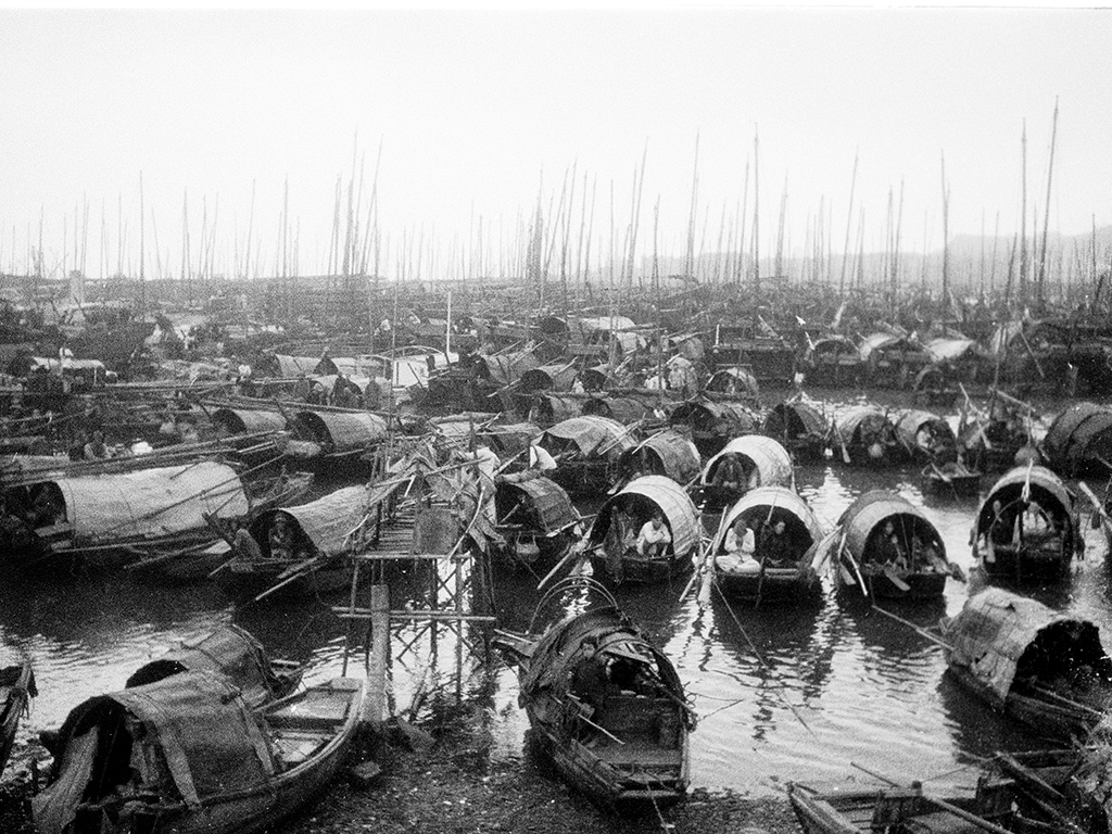
The Old Causeway Bay Typhoon Shelter
Nowadays, the Fire Dragon Path from Tung Lo Wan Road to Causeway Road is about 400 metres in straight-line distance. Before the 1950s, this area was the Causeway Bay, and one could see East Point (also known as “Goose’s Head”) on the west bank of the bay where Kingston Street and Great George Street stand today.
The bay once hosted a thriving community of boat people in the second half of the 19th century. Thousands moored their houses and fishing boats there. Typhoon casualties prompted the government to build a breakwater off the bay in 1883, and the area inside the breakwater was then known as the Causeway Bay Typhoon Shelter. In the 1950s, the government reclaimed the land around the typhoon shelter to create more recreational space and sports facilities, transforming the former Causeway Bay into the present Victoria Park, which was open in 1957. The typhoon shelter is now located on the north side of Victoria Park, where it meets Victoria Harbour.
The boat dwellers in Causeway Bay used to worship the Triangular Island Goddess of Tin Hau, a statue of Tin Hau that was moved from the Triangular Island at the mouth of the Pearl River. Tin Hau – a feminine deity, literally meaning the “Empress of Heaven” in Chinese and is also known as Mazu – is believed to bless the community with stable weather and an abundant fish harvest. The temple was famous because it was originally located on a boat anchored in the typhoon shelter. However, as the boat people shifted their lifestyle and settled on land, the temple was also “moved ashore”. The Triangular Island Goddess of Tin Hau Shrine of Peace was established on the Causeway Bay waterfront off Victoria Park Road in 2023.
Photo courtesy of The American Geographical Society library, University of Wisconsin-Milwaukee Libraries
Queen’s Recreation Ground
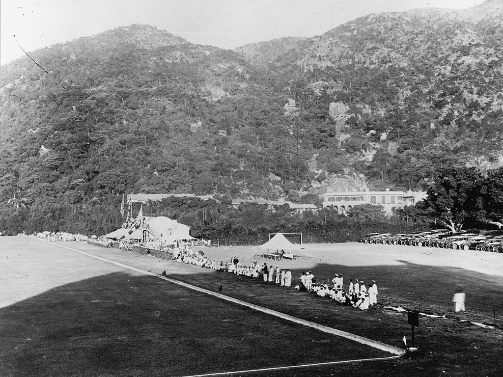
The vast area between Causeway Road and Tung Lo Wan Road has been used for recreation since the late 19th century. In 1898, to commemorate the 60th anniversary of the reign of Queen Victoria, the government converted this reclaimed, low-lying land into the Queen’s Recreation Ground for use by the British army, Police Football Club, Polo Club, etc., and opened to the public at spare time.
In the early 20th century, Hong Kong had private clubs, but recreational and sports activities were not widespread among the general public and leisure space was limited. The Queen’s Sports Ground became a popular place for many Tai Hang residents with football being one of the most popular sports there. Lee Wai Tong, a Tai Hang resident, used to have training at the Queen’s Recreation Ground. He played for the South China Football Team in Hong Kong and represented China in the Far Eastern Championship Games, where his team won the championship. Lee later became the president of the Tai Hang Welfare Association and wrote the inscription that commemorated the restoration of the current Fire Dragon Heritage Centre, which was formerly Hung Shing Yi Hok (literally, Confucius Free School for the Poor). Tai Hang played a significant role in the history of Hong Kong’s early recreational venues.
Photo courtesy of the Hong Kong Museum of History
Pavilion in the Queen’s Recreation Ground

In the campus of Queen’s College, off Fire Dragon Path, is a small red-brick building. Featuring arched frames for its doors and windows, a double-tiled roof and a rustic design, it offers a stark contrast to the modern architectural style of the adjacent school buildings. This is the Scout Den of Queen’s College. Why is it so special? The Scout Den was built long before the school buildings. It was originally a pavilion for the Queen’s Recreation Ground and is the only remaining structure from those days.
Before the Second World War, Queen’s College was located in Central. Although basic teaching and learning facilities at the time were sufficient, there was no sports ground. Instead, the students would go to the Queen’s Recreation Ground for physical exercise and sports events. In 1915, Queen’s College built a changing room for students to change clothes and rest here. With the relocation of the school building to its present site, the changing room was changed into the Scout Den, which is later accorded as a Grade II historic building.
Photo courtesy of the Moonchu Foundation and the Hong Kong Museum of History
Tai Hang Nullah
One origin of the name “Tai Hang” comes from the waterway that ran through the area. Streams from Jardine’s Lookout and Mount Butler flowed from the south to the north, forming a waterway that passed through today’s Wun Sha Street and Fire Dragon Path to Victoria Harbour.
The section of the waterway from north of Tung Lo Wan Road to Causeway Road was straightened in the late 19th century when the land was levelled for the construction of the Queen’s Recreation Ground. In the early 20th century, a number of Tai Hang residents operated laundry businesses using washing tanks built in the upstream areas on Wun Sha Street. The lower course of the waterway collected the wastewater from the laundries, function as a sewage drain. In the 1960s, the laundry business declined and the section of waterway in Wun Sha Street was covered and turned into an underground channel.
There used to be a footbridge over the channel at today’s Fire Dragon Path, known as the “Bridge on the River Kwai” where some kids would play in the channel when the water level was low. In 2013, to widen the pedestrian way and to keep away odour from the sewage, the channel was converted into an underground culvert.
Photo courtesy of Harvard-Yenching Library, Harvard University
Animation:
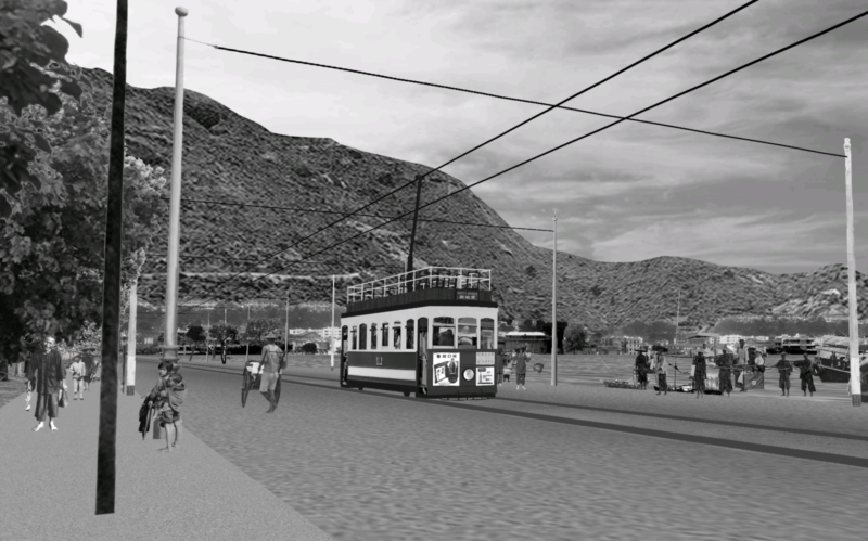
In the early 20th century, Hong Kong’s central business district was demarcated as “Victoria City”, roughly encompassing today’s Kennedy Town, Sheung Wan, Central, Wan Chai and Causeway Bay areas. Its eastern boundary was Moreton Terrace, located west of Tai Hang. Many Tai Hang residents who lived outside the commercial centre commuted into the city to work. Urban development sprawled from Central and Sheung Wan areas to the eastern side of Hong Kong Island. It brought along factories and infrastructure, such as power plants, dockyards and a sugar refinery. As the urban expansion continued, a tram line was built along Causeway Road.
In 1904, the first generation of trams was introduced, featuring a single-deck design that marked the beginning of tram services. The animation shows an third-class, cross-bench open tram, capable of accommodating up to 48 passengers without side panels. As passenger numbers grew, a second generation of double-decker trams was introduced to enhance capacity. The upper deck was open-air and featured park-style seating. The upper deck and one-third of the lower deck were designated as first-class, while the remaining seats were third-class. A total of ten double-decker trams entered service. From 1913 to 1924, both the first and second generations of trams operated simultaneously.